A five-story mixed-use project on a tight infill lot near the Durham Bulls Athletic Park stalled last year because the geotechnical report couldn't confirm bedrock depth below the saprolite. Standard borings hit refusal at inconsistent elevations, and the structural engineer needed a continuous profile to finalize the mat foundation design. We deployed a 48-channel seismic refraction line across the site and mapped the top of competent rock within 24 hours, giving the EOR the shear-wave velocity data required for Site Class determination under ASCE 7-22 Chapter 20. When drilling alone leaves gaps, seismic refraction fills them with physically meaningful P-wave and S-wave velocity cross-sections that integrate directly with the IBC Chapter 16 structural analysis.
Seismic velocity profiles give structural engineers the Vs30 value they need for ASCE 7 Site Class without subjective interpretation of SPT N-values in weathered rock.
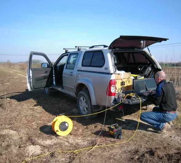
Methodology and scope
The contrast between downtown Durham's shallow diabase dikes and the deeper saprolitic weathering profile out toward Southpoint is exactly why we configure survey parameters differently for each job. In the central business district, where the Enon Formation places competent rock within 15 to 30 feet, we use a 24-geophone array with 5-foot spacing and a 16-pound sledge source, capturing first arrivals that resolve the soil/weathered-rock/competent-rock interface clearly. Farther south, where the Triassic sedimentary basin fill extends hundreds of feet before reaching bedrock, we switch to a 72-channel spread with accelerated weight drop or betsy gun sources, recording both refracted and reflected wavefields to image deeper velocity contrasts. The same fundamental physics applies everywhere, but the geometry, source energy, and processing workflow change based on the local geology that makes Durham what it is.
Local considerations
Durham's post-2000 growth pushed development well beyond the original tobacco-era core into areas where the geologic transition between the Carolina Slate Belt and the Triassic Deep River Basin creates abrupt lateral velocity changes. The 2020 Durham City-County Comprehensive Plan acknowledged that infrastructure expansion into these geologically complex zones requires better subsurface characterization than what conventional borings alone provide. We've seen sites where two borings 60 feet apart show entirely different refusal depths, and without a continuous seismic tomography line, the designer simply doesn't know whether they're dealing with a boulder, a pinnacle, or a true bedrock step. That uncertainty flows directly into foundation cost, and it's entirely avoidable with the right geophysical survey.
Quick answers
What does a seismic refraction survey cost for a typical Durham commercial site?
For a standard commercial lot in Durham County, seismic refraction surveys typically range from US$2,450 to US$6,000 depending on the array length, target depth, source type, and number of lines required. A single 24-channel line with sledge source on a half-acre site falls toward the lower end; a multi-line survey with accelerated weight drop across several acres and deeper bedrock targets approaches the upper end. We provide firm quotes based on your site plan and the specific depth of investigation the structural engineer needs.
How does seismic tomography compare to drilling for bedrock mapping in Durham?
Drilling gives you a point measurement; seismic tomography gives you a continuous cross-section. In Durham's Piedmont geology, where saprolite weathering creates irregular bedrock surfaces with pinnacles and troughs, a boring every 50 feet can easily miss a 15-foot depth variation between holes. The refraction tomogram interpolates velocity across the entire spread length, so the geotechnical engineer sees the actual bedrock profile rather than connecting dots. Most of our Durham projects combine a few borings for calibration with a seismic line for continuity.
Can you determine IBC Site Class from a seismic survey in Durham?
Yes, and this is one of the primary deliverables for our Durham projects. We use MASW or refraction microtremor methods to measure the average shear-wave velocity in the upper 100 feet (Vs30), which directly determines Site Class A through F per ASCE 7-22 Chapter 20. The Durham City-County inspections department accepts these results as part of the geotechnical submission, provided the survey is conducted under ASTM D5777 or D7128 and signed by a qualified geophysicist.
What is the difference between seismic refraction and reflection, and which one do I need in Durham?
Refraction works best when velocity increases with depth—like soil over weathered rock over competent rock—and it is the go-to method for shallow bedrock mapping in Durham's diabase and felsic gneiss terrain. Reflection is more effective when you need to image deeper stratigraphy, velocity inversions, or fault structures below 100 feet, which becomes relevant south of I-40 where the Triassic sedimentary fill extends deep. For most building foundation investigations in Durham, refraction is the right tool; for tunnel alignment studies or deep basin characterization, we recommend reflection or a combined approach.